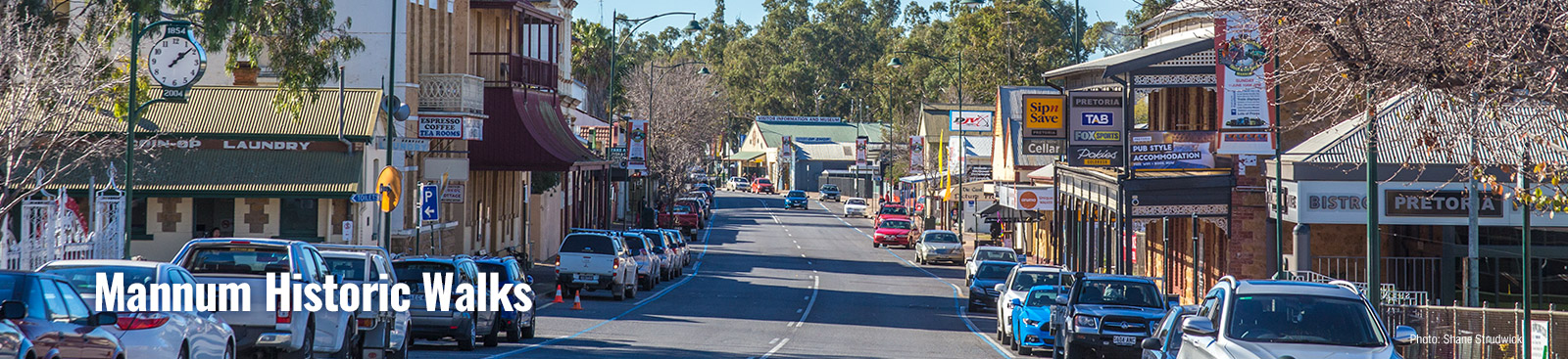
Welcome to country: I, Isobelle Campbell, Nganguraku Custodian, would like to welcome you to the land of my people. Today, Ngaut Ngaut Conservation Park, near Nildottie, can be visited by groups of ten or more. You can experience Aboriginal Culture on a journey through the ancestral home of the Nganguraku people. This experience will challenge perceptions of Aborigianal culture and leave visitors in awe of the resourcefulness of Australia’s first people. Booking 08 8570 1202.
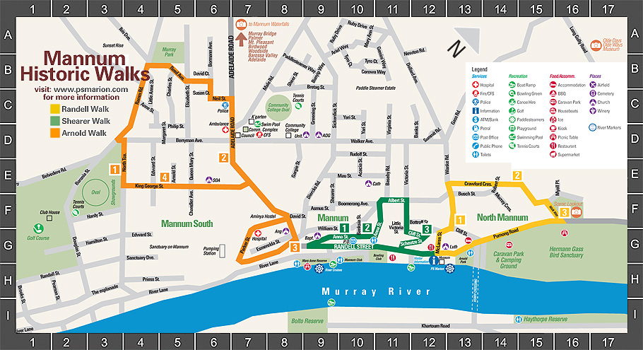
Duration: 1 – 1 1/2 hours Grade: Difficult in parts Randell Dry Dock
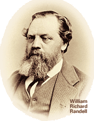
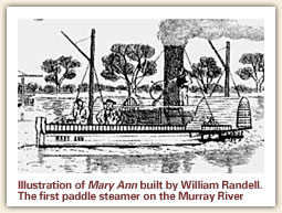
W. R. Randell built the first paddle steamer to ply the River Murray – the ‘Mary Ann’. Born in England, he was the son of a Gumeracha miller. The needs of pastoralists along the river enabled him to develop a thriving freight business. Randell built the Woolshed, the first building in Mannum, in 1854. He subdivided land, brought the Mannum Dock from Milang, and was largely responsible for the present location of Mannum, for the town grew up around his business.
Cross the street to the Woolshed. Built by Randell in 1854 to store freight to be transported on his fleet of steamers, the Woolshed was later used as a customs house, and also housed Scot’s Engineering Company.
From the Woolshed, walk up McLaren Street to the gate of Frank Randell’s house halfway up on the right. Frank Randell brought the land or this house from his brother William in 1872. In later years, he rented it out. One notable tenant was Mannum’s first Doctor, Albert Doepke, in 1873. The Scott family brought the property in 1907. Looking across to your left, part of William Randell’s Bleak House can be seen.
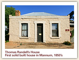
Walk to the T junction and observe Thomas Randell’s house across the road. Thomas, brother to William and Frank, opened a store in a lean-to on the Woolshed. When he was flooded out, he added two rooms to his home and used them as a bakery and general store. He bought leeches from the Aboriginal community to sell to doctors and moved to the main street about 1863.
Walk to the right and cross to the Old Manse. The original Lutheran Church, also used as a school, was built in 1882 and the manse in 1896 (enlarged in 1923). During the 1930’s the preset Church replaced the old. When major rebuilding was done in 1968 a new manse was built, but the original escaped the bulldozer.
Walk up to the asphalt track to the left of the Manse. This path is known as the Goat Track. It is one of the oldest roads in Mannum, servicing Tom Randell’s store, and continuing down to the Woolshed. It also led to the market and so was a stock track for many years It was bituminized for the first time in 2006.
Continue up Wanke Road and turn right into Crawford Crescent. You now enter a more recently developed area. From parts of this road you can see the South Mount Lofty Ranges to the west, and the River Murray Valley and flood plains to the east.
The Walkway will take you down to Purnong Road, through you may wish to continue to the Lookout first to enjoy the panoramic views. Please note that the Walkway is graded ‘difficult’.
Cross Purnong Road to the Lion’s Park and walk towards the town. To your left you will see a sign to a board walk which will enable you to view the many water birds. You are in the Herman L. Gass Bird Sanctuary. Gass was the Manager of the Mannum Club or many years, and on his retirement to Purnong Road, would feed the Pelicans. The Sanctuary was named after him and he was its first Warden. Across the road, observe the older houses, built when William R. Randell subdivided the land.
Pass the fence around the Caravan Park. Notice the old Pumphouse inside the fence. Now used as a Backpacker’s Hostel, this once housed a Crossley suction gas plant, an engine of 75 bhp and a Worthington 6 inch 3 stage centrifugal pump. It was opened in 1912.
Cross the entrance to the ferries. There was probably a punt operating before 1877, but in that year, a ferry was run by the Crown Lands Dept. Fees were charged, and clients were expected to help propel it along.
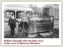
Pass the Dry Dock on your left. First used in 1876, the dock was brought to Mannum by Captain William Randell, towed from Milang behind a paddle steamer. He reported it “moved like a snake” on the journey.
Complete your walk at the Visitor Information Centre. This building was a garage for most of its life, but was remodelled as a Visitor Information Centre and Museum in 2001.
Duration: 40 minutes to an hour Grade: Average – some slopes Shearer Page
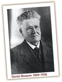
Brothers David and John Shearer were invited to come to Mannum by farmers in the area. They began their business in a small blacksmith’s shop at the top of Randell Street, moving once more before opening a factory opposite the now bowling club. Their innovative machinery revolutionised farming. They listened to the farmers and responded to their needs. Later, John moved to Adelaide, while David stayed in Mannum. David built an early steam car in the late 1800s exhibiting it in Adelaide, and frightening the local horses when he went for a spin at 15 miles per hour. Horwood and Bagshaw took over Shearers later factory on Adelaide Road in 1972.
Start: Mannum Visitor Information Centre, Randell Street.
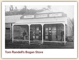
Cross the street to the Woolshed. Staying on Randell Street, cross McLaren Street to the store on the corner. This was the first store in Mannum, run by Thomas Randell (whose small white house can be seen at the top of McLaren Street). Tom ran this store with his family an also had another store in Forster (Walkers Flat).
Continue to the Bottle Shop. Note the barred windows on it’s northern side. This is the site of the first ‘jail’ in Mannum, preceding the building of a police station. Legend has it a man was chained to the floor inside. Behind this building is also the ruin of W.R. Randell’s first four room cottage. The Mannum Hotel, originally named the ‘Bogan’, was built in 1869 incorporating an earlier hotel recorded in 1866. A photograph taken in 1877 shows the building of the second storey and verandah.
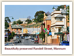
Walk along Randell Street. Observe the historical plaques which are displayed on many of the buildings. Fortunately Mannum retains much of the Main Street as it was a century ago. One of the many interesting buildings is the Institute. Instigated by the town’s leaders in 1880, it was opened in 1882 and extended in 1911. It has been used as a Council Chambers, a court, a film and picture theatre and for many other activities over the years.
Pass the site of the Shearer Factory now a car park, and continue until you turn right into the Anna Street Walkway. Enjoy the view of the main street and the Mary Anne Reserve, noting the cairns and the rotunda. In earlier years, the reserve boasted a swimming pool, a wading pool an a diving towner. Across the river, the dairy farming flats, and highlands can be seen. River levels rise and fall frequently, but in 1956 much of the town was under water.
Continue to the small lookout above the Shearer factory site, turn left and walk up the hill. The large white house on your right was the Shearer residence. It still boasts the remains of ay observatory.
Continue up the lane to William Street.Turn right and enter Albert Street. You may need to cross the road to find a safe pathway.
Turn right into Victoria Street.
Continue walking until Victoria Street bends into Cliff Street. Notice the old school building.
Walk down Cliff Street and turn right into Schuetze Street. At this junction you can see the foundations of William Randell’s first four roomed cottage behind the hotel. Schuetze Street takes you past many old cottages on your right. and the rear of the old bakery as your enter Randell Street.
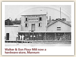
Turn left and continue back to the Visitor Information Centre. You may wish to cross the road to see the buildings on that side. Points of interest include the Butter Factory, reminding us of the dairy industry across the river, and the Pretoria Hotel, the name of which is associated with the Boer War. The ‘P.S. Nellie’, built in 1882 and used as a travelling store by Captain Crane, used a wharf built on the riverside nearby. She was purchased by Arnold in 1919 and destroyed by fire together with the ‘Ellen’ at Morgan in 1930. As you return to the Visitor Information Centre, take special note of the building which was originally Walker’s Flour Mill. Benjamin Walker built it from 1874-6 and equipped it with machinery brought from the Waymouth Street Mills in Adelaide for 600 pounds. That machinery was originally steam driven. Ben’s son John was in charge of this mill. It closed in 1978.
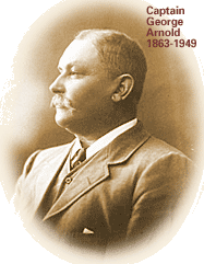
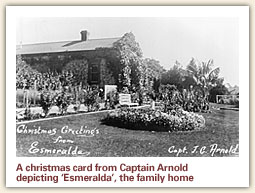
John George Arnold, known as George, arrived in Murray Bridge in 1899 with qualifications allowing him to captain any ship throughout the world. he was first employed on the Tyro’ under Captain Murray Randell, but soon became a ship owner and builder in Mannum, obtaining contracts from the government also engaging in salvage work. He subdivided land, built houses for his workers, and was heavily involved in the sporting and community activities of the town. He lived at Esmeralda and later provided some of it’s land from the hospital.
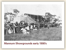
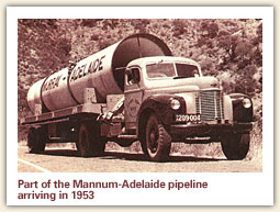
Start: The Memorial Gates, Mannum Showgrounds, North Terrace. The showground has not only hosted agricultural shows for many years, but was the accommodation base for workers on the water pipeline in the 1950s and today is used by many community and sporting groups.
Walk up to the junction of Berryman and Ramm Road. Continued up Ramm Road past Anne and Little Anne Streets. Follow the sign pointing right to Murray Park. Walk between the rocks and the small park until you reach Reed Avenue which leads off Elizabeth Street. Turn right. Notice the Mannum – Adelaide Water Pipeline, completed in 1954.
Cross Elizabeth Street near the pipeline and walk along the dirt track leading to Bormann Avenue. Cross Bormann Avenue and walk down to Neil Street. The Gem ad Mineral Gallery is well worth a visit.
Continue down Neil Street to Adelaide Road. The Police Station was built in 1980 and replaces the earlier one which stood on the site of the present motel opposite the Ferry.
Turn right and continue past the Police Station. Note the Leisure Centre and Council Chambers across the road.
Continue to King George Street. Near the pedestrian crossing you will notice the Horwood Bagshaw factory, originally the second Shearer factory, opened in 1910.
Continue on Adelaide Road past the Aminya Complex (begun in 1990 to provide homes for the aged) to the Hospital entrance. Before 1920, a number of private facilities cared for the sick, the injured and those needing maternity care. A public meeting in 1914 resulted in a committee that oversaw the building of the hospital which opened six years later. Funding came mainly from the community with a subsidy from the Government. Dr. Sprod guaranteed the 525 pounds required to build an operating theatre.
Continue to the War Memorial. Plaques on the Memorial foundation, and on the wall, provide information.
Walk past the Memorial to the green lamp post. This location provides a good view of Esmeralda, once the Arnold family home.
Return up the hill and turn left into Parker Street. The Mannum to Adelaide water pumping station opened in 1998. It’s worth noting the buildings and streets which have been cut into the river cliffs around Mannum.
The Parker Street loop will return you to the Adelaide Road. Turn left. Turn left again into King George Street. At the corner of Chandler Avenue are two small identical buildings with concrete pavement frontage. These were the ‘Four Square’ Store and Male’s Butcher Shop which accommodated the needs of many residents, especially during the building of the water pipelines to Adelaide.
Cross the road to Arnold Street. You will notice the ‘Seven Sisters’, a group of seven identical homes build by George Arnold in 1911 to accommodate his workers. This area is part of a large subdivision of Arnold’s land which he bought in 1908 and registered as ‘Mannum South East’ in 1910.
Continue along King George Street to North Terrace and turn right to return to the Showground Oval.